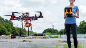
In recent years, drone software has emerged as a cutting-edge technological tool with the potential to transform various industries. One such area where drone software can make a significant impact is wildlife conservation.
Advanced drone software can revolutionize the way we approach and manage wildlife conservation efforts, offering improved monitoring capabilities, cost savings, and reduced impact on natural environments.
Get the latest articles in your inbox fresh and ready to read …
Get the New To Drones "All Access Pass"
All Access Pass members enjoy unlimited access to entire articles – 100% FREE
By signing up you agree to our Terms of Service and Privacy Policy. You also agree to receive our newsletters (you can easily and quickly opt-out at any time).
You will receive free access to all of our articles while you are a member of the site.
Benefits of using advanced drone software for wildlife conservation
Improved monitoring capabilities
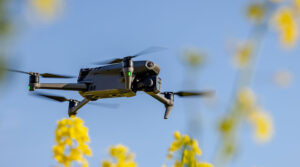
One of the most significant advantages of using drone software for wildlife conservation is the improved monitoring capabilities it offers. By providing increased accuracy and range of data collection, real-time tracking, and analysis of animal activity, and the ability to identify changes in habitats over time, drone software can greatly enhance conservationists’ ability to monitor and protect wildlife populations.
Increased accuracy and range of data collection
Traditional methods of data collection in wildlife conservation, such as ground surveys and camera traps, are often time-consuming, labor-intensive, and limited in the scope of information they can provide. Drone software, on the other hand, enables conservationists to capture high-resolution aerial imagery and gather valuable data over vast areas quickly and efficiently. This improved data collection capability allows for more accurate assessments of wildlife populations, habitats, and trends, leading to better-informed conservation decisions.
Real-time tracking and analysis of animal activity
Drone software also provides conservationists with the ability to track and analyze animal activity in real-time. This is particularly useful for monitoring species that are difficult to observe or track through traditional methods, such as elusive or nocturnal animals. Additionally, real-time tracking can help identify patterns of movement and behavior, which can be crucial for understanding the needs of specific species and implementing targeted conservation efforts.
Ability to identify changes in habitats over time
By utilizing drone software to regularly monitor wildlife habitats, conservationists can identify changes in various environmental factors, such as vegetation cover, water availability, and human encroachment. This information can be invaluable for detecting early signs of habitat degradation or loss, allowing conservationists to take proactive measures to protect vulnerable ecosystems and prevent further decline in wildlife populations.
Cost savings associated with increased efficiency
In addition to its monitoring benefits, advanced drone software can also lead to significant cost savings in wildlife conservation efforts. By automating data collection processes, reducing the need for physical infrastructure, and minimizing the risk associated with dangerous fieldwork activities, drone software can help conservation organizations allocate their resources more effectively and maximize the impact of their conservation initiatives.
Reduction in labor costs due to automated data collection processes
The use of drone software in wildlife conservation can greatly reduce labor costs associated with data collection. Traditional data collection methods often require teams of researchers to spend long hours in the field, sometimes in remote and challenging environments. By automating these processes, drone software not only saves time but also reduces the need for large teams of fieldworkers, resulting in significant cost savings for conservation organizations.
Minimized need for physical infrastructure such as observation towers or ground surveys
Drone software also minimizes the need for expensive physical infrastructure, such as observation towers, vehicles, and other equipment needed for ground surveys. By providing high-resolution aerial imagery, drone software allows for detailed analysis of wildlife habitats and populations without the need for on-the-ground infrastructure, further reducing costs and logistical challenges associated with traditional conservation methods.
Lower risk associated with dangerous fieldwork activities
Wildlife conservation fieldwork can often be dangerous, with researchers at risk of injury from encounters with wildlife, hazardous terrain, or extreme weather conditions. Drone software can significantly reduce these risks by allowing conservationists to remotely monitor wildlife populations and habitats, minimizing the need for potentially dangerous fieldwork activities.
Reduced impact on natural environments through remote sensing techniques
Finally, the use of advanced drone software in wildlife conservation can help reduce the impact of human activities on natural environments. Remote sensing techniques, such as aerial imagery and thermal imaging, allow conservationists to gather valuable information about wildlife populations and habitats without physically entering sensitive ecosystems. This minimizes disturbances to wildlife and reduces the risk of habitat degradation due to human presence, thereby contributing to more sustainable and effective conservation efforts.
Potential applications for advanced drone software in different areas of wildlife conservation
Species identification & population management
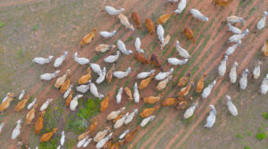
Advanced drone software can significantly improve species identification and population management efforts in wildlife conservation by providing real-time, accurate data on endangered species, estimating population sizes, and assessing and mitigating human-wildlife conflicts.
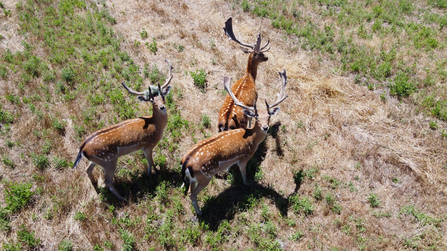
A. Identification and monitoring of endangered species
Drone software allows conservationists to remotely monitor endangered species, reducing the need for invasive tracking methods that can be stressful for animals. High-resolution aerial imagery and thermal imaging can be used to identify individual animals, track their movement, and monitor their behavior, providing valuable data for conservation planning and decision-making.
B. Estimation of population sizes based on patterns detected by drones
By analyzing the patterns and movements of wildlife detected by drones, conservationists can estimate population sizes with greater accuracy than traditional methods. This information can be used to assess the conservation status of various species and develop targeted management strategies to protect endangered populations.
C. Assessment & mitigation strategies for mitigating human/wildlife conflicts
Drone software can also help conservationists identify areas of potential human-wildlife conflict, such as agricultural lands, urban areas, or transportation corridors where wildlife may be at risk. By providing real-time data on wildlife movements and habitat use, drone software can inform the development of mitigation strategies to reduce conflict and promote coexistence between humans and wildlife.
Habitat protection & restoration
Advanced drone software can play a crucial role in habitat protection and restoration efforts by detecting and mapping invasive plant species, monitoring land cover change over time, and assessing water quality levels and vegetation health.
Detection & mapping of invasive plant species
Drone software can be used to detect and map the distribution of invasive plant species, which can threaten native ecosystems and wildlife populations. Early detection of invasive plants can enable conservationists to develop targeted control and eradication strategies, preventing further spread and minimizing ecological impacts.
Monitoring land cover change over time
By regularly monitoring land cover change using drone software, conservationists can identify areas of habitat degradation or loss and take proactive measures to protect and restore wildlife habitats. This information can also be used to assess the effectiveness of conservation interventions and inform future habitat management strategies.
Assessing water quality levels and vegetation health
Drone software can be used to remotely assess water quality levels and vegetation health in wildlife habitats, providing valuable information on ecosystem health and function. This data can inform habitat restoration efforts and help conservationists prioritize areas for intervention.
Research Initiatives
Advanced drone software can support various research initiatives in wildlife conservation by collecting data from hard-to-reach locations, tracking migratory patterns or behaviors across large landscapes, and enhancing public outreach initiatives related to environmental education.
Collecting data from hard-to-reach locations
Drones equipped with advanced software can access hard-to-reach locations, such as remote or rugged terrain, where traditional data collection methods may be challenging or impossible. This can provide valuable insights into wildlife populations and habitats that were previously unattainable, contributing to a more comprehensive understanding of conservation issues.
Tracking migratory patterns or behaviors across large landscapes
By providing real-time tracking data over large landscapes, drone software can help researchers track migratory patterns and behaviors of various species. This information can be used to identify critical habitats and inform the development of conservation strategies to protect migratory species.
Enhancing public outreach initiatives related to environmental education
Drone software can also be used to enhance public outreach and environmental education initiatives by providing engaging and informative visual materials, such as high-resolution aerial imagery and videos of wildlife habitats and behaviors. This can help raise awareness of wildlife conservation issues and inspire public support for conservation efforts.
Cleared for Takeoff
Advanced drone software has the potential to transform wildlife conservation by providing more accurate, efficient, and cost-effective methods for data collection, monitoring, and management. By harnessing the power of this cutting-edge technology, conservationists can develop more effective and sustainable strategies to protect our planet’s precious wildlife for generations to come.